ESC
Wiki quality control
| Has flag | yellow |
|---|
Name, responsible organisation and contact person
| Has full name | Ecological Site Classification |
|---|---|
| Has acronym | ESC |
| Has wiki contact person | Sibhatu Abera |
| Has wiki contact e-mail | sibhat21@yahoo.com |
Software identification
| Has software | ESC.Software |
|---|
Description
| Has description | ESC is a PC-based DSS software can be accessed via a web browser, that supports a methodology for the evaluation of the suitability of different tree species and woodland communities as defined in the National Vegetation Classification (NVC) for Great Britain, predicting yield in the form of a site index, on the UK forest land and also future climate analysis . This tool encourages the decision makers on the election of a suitable forest species according to their site soil properties and climatic data, instead of selecting an inadequate species and then trying to modify site characteristics to make it more suitable. It also provides the suitability of the species according to the expected evolution of the climate, and predicts the potential yield in the form of a site index. The number of tree species considered is 25, and there are also 20 native woodland types. |
|---|---|
| Has modelling scope | Forest indicators, Ecological indicators, Social indicators |
| Has temporal scale | Long term (strategic), Medium term (tactical), Short term (operational) |
| Has spatial context | Spatial with no neighbourhood interrelations |
| Has spatial scale | Forest level, Regional/national level, Stand level |
| Has objectives dimension | Multiple objectives |
| Has related DSS | ESC |
| Has goods and services dimension | Market wood products, Non-market services |
| Has decision making dimension | More than one decision maker/stakeholder |
| Has forest management goal | afforestation management, climate change impact, ecological classification, economic evaluation, fertilization, forest ecology, wood supply planning |
| Supports tree species | 20-25 |
| Supports silvicultural regime | even-aged, uneven-aged/natural regeneration, uneven-aged/plantation |
Concrete application
| Has typical use case | 01 |
|---|---|
| Has user profile | Non-industrial private owners, forest owners associations, private legal entities (cooperatives / corporations / trusts / partnerships / condominium associations), commons, public land managers (i.e. state-owned / federal / cantonal / communal forests), national forest administration, NGO, service providers, local communities, local administration, IT company, other |
| Has country | United Kingdom |
| Has references about examples of application | An Ecological Site Classification for Forestry in Great Britain”, Graham Pyatt, Duncan Ray and Jane Fletcher, Forestry Commission Bulletin 124, 2001 |
| Has number of users | >100 |
| Has number of real-life applications | >100 |
| Has utilisation in education | used by students |
| Has research project reference | REYNOLDS K.M., TWERY M., LEXER M.J., VACIK H., RAY D., SHAO G,. et BORGES J.G.: Decision Support Systems in Forest Management IN BURSTEIN F. et HOLSAPPLE C. W. (EDS.) (2008): Handbook on Decision Support Systems 2: Variations. Springer Berlin Heidelberg. 800 pp.
↑ REYNOLDS K.M., TWERY M., LEXER M.J., VACIK H., RAY D., SHAO G,. et BORGES J.G.: Decision Support Systems in Forest Management IN BURSTEIN F. et HOLSAPPLE C. W. (EDS.) (2008): Handbook on Decision Support Systems 2: Variations. Springe |
| Has tool dissemination | allow the forest manager to use advanced decision support tools, such as expert and knowledge based systems, multi-criteria techniques as well as communication and visualization tools. European experience with developing and applying forest DSSs for forest management provides a solid foundation for |
Decision support techniques used in the DSS
| Has decision support techniques | ESC.Decision support techniques |
|---|
Support of Knowledge Management
| Has knowledge management processes | ESC.Knowledge management process |
|---|
Support of social participation
| Has support for social participation | ESC.Support of social participation |
|---|
DSS development
| Has DSS development | ESC.Description of DSS development |
|---|
Documentation
| Has website | http://www.forestry.gov.uk/fr/esc |
|---|---|
| Has online demo | https://www.eforestry.gov.uk/forestdss?app=esc |
| Has manual | Yes |
| Has technical documentation | Yes |
| Has reference | [[Has reference::* ESC project website |
General System description
Contents
- 1 Wiki quality control
- 2 Name, responsible organisation and contact person
- 3 Software identification
- 4 Description
- 5 Concrete application
- 6 Decision support techniques used in the DSS
- 7 Support of Knowledge Management
- 8 Support of social participation
- 9 DSS development
- 10 Documentation
- 11 General System description
- 12 Data and data models
- 13 Models
- 14 Decision Support
- 15 Output
- 16 System
System origin
- The system was developed in the 1990s but the origins can be traced to a publication by Anderson in the 1950s and earlier works that identified relationships between site quality and vegetation.
It is developed by the Forestry Commission Research Agency, in a team led by Duncan Ray. - ESC in its 1.7 version is available for purchasing at the ESC website for the price of 100£.
Currently, version 2.0 is free to use at stand scale via web as part of the GB Forestry DSS tools. - Both the U.K. Forestry Standard and the U.K. Woodland Assurance Scheme support the use of ESC as an objective methodology for both the software objectives above described[1].
Support for specific issues
Species suitability and selection, biodiversity, and climate change effects on species suitability.
Support for specific thematic areas of a problem type
- Silvicultural
- Certification
- Conservation
- Restoration
- Development choices / land use zoning
- Policy/intervention alternatives
Capability to support decision making phases
- Intelligence
- gives user detailed site analysis (climate and soil parameters).
- Design
- provides site analysis in context of many themes.
- Choice
- allows user to vary species choice, management options.
- Monitor
- highlights risks which in theory could encourage monitoring.
Related systems
Describe (and/or link to) other systems related
Data and data models
Typical spatial extent of application
In the U.K. ESD-DSS is used for forest scenario planning, from the strategic national and regional scales to landscape-scale analyses through to suitability assessments on a site-by-site basis.
Web based tool operates at stand scale, ca 1-5 hectares, batch GIS tool has generated regional and national scenarios.
Type of information input from user (via GUI)
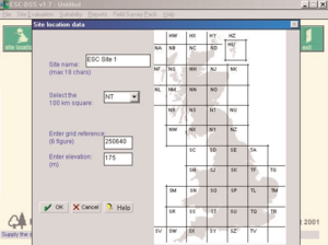
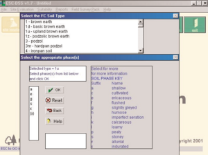
Users only have to input information about site grid reference, elevation, and soil features. Soil quality can be estimated approximately from some quick observations made of the soil and vegetation at the site, or can be predicted more accurately with a complete description of soil type, lithology, humus form and existing plants.
Models
Forest models
The site information is linked to ESC suitability models for 20 of the 25 NVC woodland communities (W1-W20) and 25 species of tree using a 'fuzzy membership function' approach. The fuzzy membership function describes the degree of suitability of the species or woodland community to each ESC site factor.
Species suitability and yield prediction models are based on accumulated temperature (AT5), moisture deficit, continentality (CT), wind exposure (DAMS - Detailed Aspect Method of Scoring system, a function of elevation, topographic exposure, aspect, funneling effects and wind zone classification across Britain), moisture deficit (MD), soil moisture regime (SMR) and soil nutrient regime (SNR). From these six variables, climatic warmth (accumulated temperature) is assumed as the principal factor and from the remaining others only the most limiting factor may modify the site yield prediction [2].
The link between biophysical factors and tree species suitability is defined by a set of knowledge based rules that represent an accord based on the combined discussion of a panel of forest scientists with knowledge and experience of the site-related growth potential of the 25 tree species presented. ESC site-yield estimates have been judged acceptable by many foresters and scientist at the ESC courses and demonstrations across a range of climatic zones and site types in the U.K. The model of Sitka spruce was also tested in the Clashindarroch Forest, in Aberdeenshire (Scotland), showing a slightly underestimated site-yield approach[3].
Decision Support
Definition of management interventions
Species or NVC woodland choice.
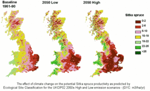
Prescription enumerating all selected possibilities at stand level, or thematic GIS layers (e.g., Oak or Sitka Spruce suitability in a defined area of interest), even reaching national level.
Typical temporal scale of application
Has support for future climate scenarios, being the baseline data from 1961-1990.
Types of decisions supported
- Management level
- strategic decisions
- administrative decisions
- operating control decisions
- Management function
- planning decisions
- organizing decisions
- command decisions
- control decisions
- coordination decisions
- decision making situation
- unilateral
- collegial
- Bargaining / participative decision making
Output
Types of outputs
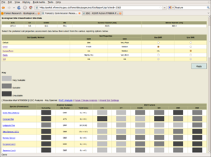
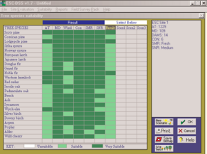
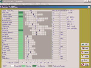
Stand version generates tables showed on screen. Thematic maps can be generated via a batch tool for visualisation in GIS, assuming suitable soil data is available.
Spatial analysis capabilities
It has been implemented within ArcView 3.*™, and allows a lot of spatial analyses like in the image above showed.
System
System requirements
- Microsoft® Windows® 3.1, 95, 98, or NT4
- 486 processor or better
- 4 Mbytes free hard disk space
- 8 Mbytes RAM (minimum)
- CD-ROM drive
- Web tool only requires a web browser.
- GRASS GIS or ArcView 3 required for batch stage. Data currently managed in Oracle database or as raster files.
- Development status: ESC-DSS version 1.7 is available for purchasing. Version 2 is available on the Internet and is being updated.
Architecture and major DSS components
ESC 1.7 was written in C++. It has been implemented within ArcView 3.*™ and GRASS.
ESC 2.0 is written in Java and has a web based UI using JSP, HTML, CSS.
ESC 4.0 is based on an open source GIS tools stack comprising openlayers, geoserver, postgis and geotools. QGIS and R are used in the data preparation stages. Spatial data are available as web map services (WMS) for use in desktop GIS (e.g. QGIS) via http://www.forestdss.org.uk/geoserver/wms.
Usage
Used in education, public and private sector forestry and research.
Computational limitations
Longer runtime to compute national datasets.
User interface
Web UI requires some understanding of soil types, OS grid references, reference to geological maps. Interpretation of information can be challenging so support is being developed.
Documentation and support
Bulletin 124 describes the method, and version 1.7 is well documented[4]. There is also a Field Survey Pack in order to help users to understand the ESC data requirements.
Version 2.0 no formal training available to date. Support available via email.
Practical training courses on ESC-DSS are organised by Forestry Training Services (a part of the Forestry Commission) at various locations around the UK. Courses cover ESC survey techniques, soil and plant identification, and tree species and native woodland community suitability.
Installation
- Server installation requires J2EE server such as Tomcat or Oracle Application Server and an oracle database, and requires specialized skills and tools. Batch mode requires some configuration on host machine.
- Web tool requires web browser.
Cite error: <ref> tags exist, but no <references/> tag was found
